


Quick Links
Understanding your rights of way and access
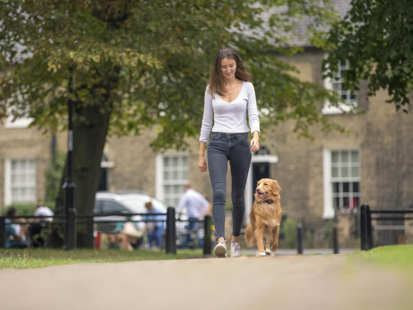
Bored of plodding along the same old dog walk? Smelt all the good smells? Nothing good to look at?
Fear not – we’re here to help you switch up your routine and find exciting new adventures for you and your furry friend within walking distance of your home.
No matter where you live, there’s always a new area to be explored nearby. Whether you’re a city dweller or live slap bang in the middle of a National Park (you lucky thing!), a local map and a bit of adventurous spirit are all it takes to find somewhere new to walk.
To help you out, we’ve put together our top tips for finding those new routes, including some essential map reading and navigation skills.
Reading a map
Your first step in finding a new dog walk is a high-quality map that has walking routes and rights of way plotted on it. In the UK, the Ordnance Survey is the national mapping agency and tends to have the best maps for helping you find walking routes.
If you don’t have a paper map of your local area, you can use the Ordnance Survey maps on Bing Maps or download the OS Maps app to your phone.
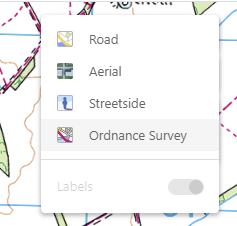
Toggle Ordnance Survey maps by clicking on the ‘Road’ icon in the top left-hand corner of Bing Maps and changing the selection to ‘Ordnance Survey’.
To the novice map reader, an Ordnance Survey map could look fairly daunting. However, with a bit of practice, you’ll soon be reading it like your favourite book.
If you’re new to map reading, you’ll want to start off by understanding the many different symbols and lines that you would see on a map. The Ordnance Survey has a fantastic resource for new map readers to get you started, or you can use the legend found on paper maps to guide you.
Understand your rights of way and access
In the UK there is a network of paths and tracks where the general public have a legally protected right to walk. Some of these paths are also open to cyclists, horse riders and motorists, depending on the type of right of way provided.
Public rights of way are marked on OS maps using a variety of different symbols to show you what type of right of way it is. These can be found on the legend on the map, but for a 1:25K map (such as the Ordnance survey ‘Explorer’ maps) the paths and tracks with their public rights of way access are marked as follows:
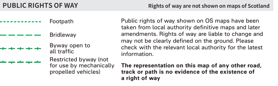
Credit: Ordnance Survey
You’ll also see markings for other types of public access. These routes are accessible by the public and often join up rights of way. These routes are usually open for constant public use but don’t necessarily entitle a right of way so could be subject to restrictions put in place by the landowner or local authority.
These types of public access are marked on 1.25K maps as follows:
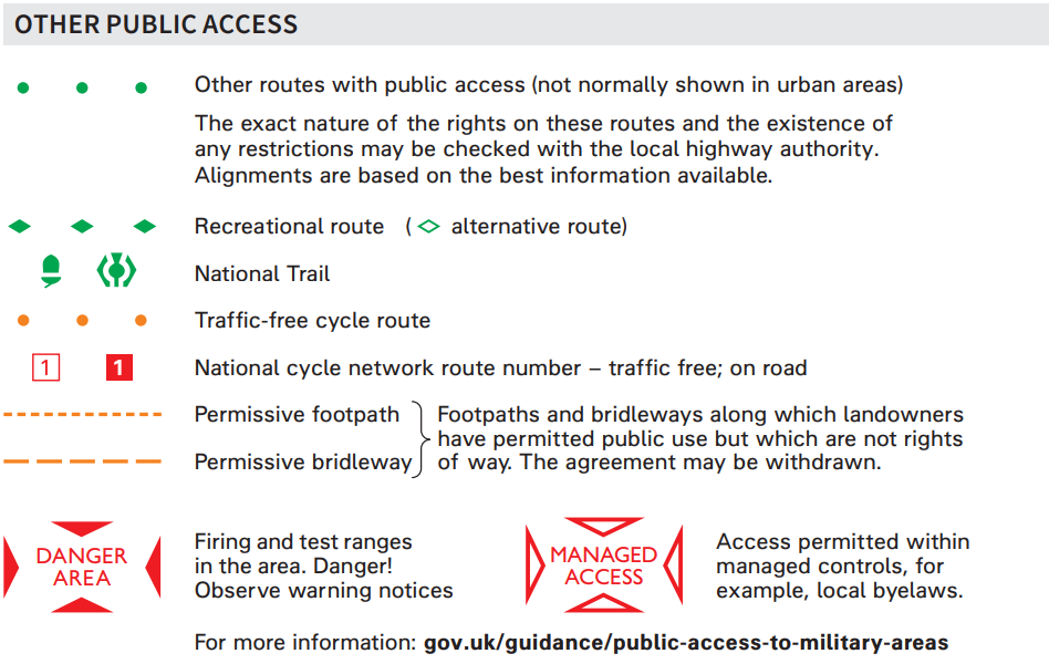
Credit: Ordnance Survey
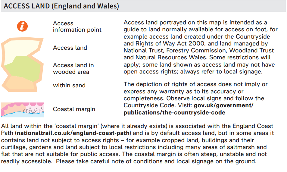
Finally, there are pockets of open access land throughout the UK, where the public has the right of access to explore, meaning you don’t need to stay on designated tracks within those areas.
On an OS map, open access land can be identified by a semi-transparent outline and ‘wash’ across a patch of land. This can be of varying colours depending on the type of terrain.
Credit: Ordnance Survey
Access in Scotland
Public access in Scotland functions slightly differently to the rest of the UK. Instead of having different levels of prescribed access, everybody has access rights over most land and inland water (such as rivers, lakes and more) provided access is exercised responsibly. This applies to walking, cycling, horse riding and water access but not to motorised activities, hunting, shooting or fishing. Importantly your dog must be under proper control at all times.
Finding a local route
OK, so you understand how to read a map and identify the different levels of access – now you need to apply it to find yourself a new route. Here’s our step-by-step guide to finding a great new dog walk.
Step 1 – Look for paths and tracks near your home that lead away from roads into green spaces. Even if you live in a city, you should be able to find local parks where you can get away from traffic and even exercise your dog off lead.
Step 2 – Look for potentially interesting sights along the way that will be pleasant for you and your dog, such as lakes and river crossings, wooded areas and open pastures they can roam in. Try and avoid walking alongside or crossing busy roads as much as possible.
Step 3 – Try and create a circular route that starts and ends at home (or wherever the start point of your walk may be). You’ll get to see new things and shouldn’t have to repeat long stretches of the walk. That said, if it’s safer to come back the same way you went in, or it’s difficult to make a loop, it’s perfectly fine to double back on yourself.
Step 4 – Pay close attention to the contours and other features on the map so you can be fully prepared for your walk. For example, check the contours to see if you’ll be going up a hill and see how steep the ascent is, or look out for symbols showing crags that may be difficult for you and your dog to traverse.
Step 5 – Check how long your walk will take you. The easiest way to do this is by using the OS Maps app or a route plotter – just plot your route using the tool and it will usually give you a distance, total incline and decline and the estimated time it will take to complete. Make sure the length of your walk is suitable for your dog – whilst some dogs will gladly bound up a mountain with you, others would struggle with such intense activity. If in doubt, use the PitPat app to check their recommended daily exercise goal or ask your vet.
If you don’t have access to a digital route plotter you can find out the length of your route using a paper map and a piece of string. Once again, the Ordnance Survey comes to the rescue with a handy guide to doing just this.
Follow an existing route
If you don’t fancy plotting your own route, there are plenty out there that have already been done for you – so all you have to do is follow the path laid out in the walking description. Here’s a selection of popular sources for finding local walking routes:
- ‘Discover Routes’ within the OS maps app
- National Trust walking routes
- Walking Britain
- UKHillWalking
- OS Pathfinder Guidebooks
- Ramblers Walks
On your walk
Once you’ve planned your route, there’s only one thing left to do – walk it!
Before setting out make sure you’ve got everything you’ll need, such as:
- Collar, harness and lead for your dog
- Bottle of water and a collapsible dog bowl
- Bag of treats – some for you and some for your pup
- A map and a compass (especially if your route is taking you away from developed areas)
- Your mobile phone, with plenty of charge
- Bright clothing, especially if you are walking in very rural areas or darker hours of the day
- A small first aid kit, particularly if walking in rural areas and/or if you plan to be out for a while
- A PitPat Dog GPS Tracker for your pup and a fitness wearable for you – so you can see how many treats you’ve both earned at the end of the day
Whilst on your walk, check your map occasionally to make sure you don’t take a wrong turn. Observe local signage and be prepared to make diversions – for example, if dogs must be kept on a lead around livestock or nesting birds.
Keep an eye out for features along your route that will show you that you are on the right path, such as rivers, lakes, bridges, monuments, churches and more.
Most importantly – have fun! You might just find a hidden gem close to home that you had never noticed before and your pup will love the new smells, sights and sounds along their new walk.